Thank you for posting these maps, Matt. I'm glad Board members finally received the information that a number of the Phase III subcommittees requested repeatedly without receipt, and which led to one of the committee's creating a population density map to the best of its ability. Those maps were, I'm sure you recall, much maligned because of their origin. So I'm glad "official" maps are now out there for reference.
As I look at the maps, and in light of the walkability issue and our current economic forecast--cuts even if/when an operating levy passes--I have a question. How do these maps change the number of crossing guards necessary to get elementary kids to school safely? In the last few years, fewer intersections have the benefit of a crossing guard. These guard positions were eliminated for financial reasons. What determines where a guard is posted? Will we need more guards if one plan or another is selected? If so, how does that affect our bottom line when we will begin making cuts that get closer to programs than we'd like?
It seems like we would want to keep neighborhood kids together as much as possible, walking away from major roads as much as possible. I notice that one scenario affecting three schools splits blocks in the North/South direction, so half the kids travel one way and half the other. This diminishes the possibility that families create Walking Schoolbuses, or that kids just meet up on the way to school for the safety in numbers effect. One scenario requires a lot of children to cross Detroit who otherwise would not have to. I get that crossing guards aren't bringing home the big bucks, but at this point every dollar counts. Thoughts?
Thanks again for posting the information and comments.
Christina
A "Phase III Maps" Response
Moderator: Jim O'Bryan
-
Christina McCallum
- Posts: 102
- Joined: Sat Mar 18, 2006 4:42 pm
-
marklingm

- Posts: 2202
- Joined: Sat Jul 07, 2007 7:13 pm
- Location: The 'Wood
Re: A "Phase III Maps" Response
Christina McCallum wrote:Thank you for posting these maps, Matt. I'm glad Board members finally received the information that a number of the Phase III subcommittees requested repeatedly without receipt, and which led to one of the committee's creating a population density map to the best of its ability. Those maps were, I'm sure you recall, much maligned because of their origin. So I'm glad "official" maps are now out there for reference.
As I look at the maps, and in light of the walkability issue and our current economic forecast--cuts even if/when an operating levy passes--I have a question. How do these maps change the number of crossing guards necessary to get elementary kids to school safely? In the last few years, fewer intersections have the benefit of a crossing guard. These guard positions were eliminated for financial reasons. What determines where a guard is posted? Will we need more guards if one plan or another is selected? If so, how does that affect our bottom line when we will begin making cuts that get closer to programs than we'd like?
It seems like we would want to keep neighborhood kids together as much as possible, walking away from major roads as much as possible. I notice that one scenario affecting three schools splits blocks in the North/South direction, so half the kids travel one way and half the other. This diminishes the possibility that families create Walking Schoolbuses, or that kids just meet up on the way to school for the safety in numbers effect. One scenario requires a lot of children to cross Detroit who otherwise would not have to. I get that crossing guards aren't bringing home the big bucks, but at this point every dollar counts. Thoughts?
Thanks again for posting the information and comments.
Christina
Christina,
You are welcome, and you raise good points. The maps certainly seem to speak for themselves. And I will inquire as to the crossing guard questions.
Matt
-
marklingm
- Posts: 2202
- Joined: Sat Jul 07, 2007 7:13 pm
- Location: The 'Wood
Re: A "Phase III Maps" Response
Mike Davis wrote:A hanful of kids walking a little farther to school should not be the deciding factor of which school should be rebuilt. It is too small a number to sway a decision one way or another. The tax payors of Lakewood expect the BOE to take into account the financial stewardship of assets, as well as many other important considerations.
http://www.lakewoodobserver.com/forum/viewtopic.php?f=7&t=8791&start=15
Mike,
I agree with you. And, if you compare the two maps, the map representing what the school district configuration would look like if Lincoln closed today ensures that only a handful of kids will be walking a little farther to school as Bill Trentel correctly explains when he says:
Bill Trentel wrote:[T]he map with the central school would seem to force the two north (Horce Mann and Emerson) school boundaries to be geographically much larger but this is only because they are located in areas that are far less densely populated by students. The Gold Coast, the apartments on eastern Clifton Blvd. and Lakewood Park just aren't were students live. Likewise the central and three south schools geographic boundaries appear to be smaller and that is because they are located in areas that are more densely populated by students.
Bill Trentel’s analysis explains the following map very well:
The map representing what the school district configuration would look like if Lincoln closed today, is as follows below:
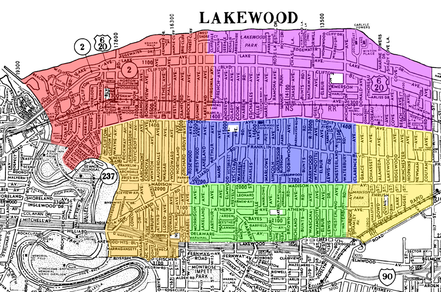
overlays ©2010 AGS
------------------------------------------------------------------------------------------------------------------------------------------------
And, of course you are correct, Mike, the Board is expected to take into account the financial stewardship of assets, as well as many other important considerations. To that end, it may actually cost the taxpayers more to rebuild Lincoln than Grant for the reasons Bill Trentel explains:
Bill Trentel wrote:At the November BOE meeting the districts architect consultant presented rough outlines of each of the two locations in question. He said that the use of either site would require a totally new building. The small Lincoln site would require a three story building and would need to be placed off center on the site in-order to achieve the require amount outdoor play/activity space. His drawings indicated that 4 homes would need to be acquired, 2 on Summit and 2 on Lakeland to make the site large enough. Additionally he mentioned that construction logistics would be a challenge at the Lincoln site due to the lack of space to stage materials and place construction trailers and equipment. His Grant location drawings did not indicate the need for any additional property and the building would be two story. The size of the site would allow more flexibility in the design and placement of the building.
http://www.lakewoodobserver.com/forum/viewtopic.php?f=7&t=8791&start=30
So, as Bill Trentel asks:
Bill Trentel wrote:Now that we've hashed-out the location element...
Some posters have implied that there are other issues that makes one location superior to the other, what are they?
We've be told by the BOE consultants that either site is build-able and financially a wash. And commercial value of either site has not been determined but assumed to be a wash. And both schools have great students, parents and staffs that achieve. What other facts are out there?
Matt
-
Mike Davis
- Posts: 45
- Joined: Wed Jan 21, 2009 11:18 pm
- Location: Lakewood
Re: A "Phase III Maps" Response
Matt, it is abundantly obvious to this parent of school age children, that the walking distances will be shorter for children attending all 6 elementary schools by rebuilding Lincoln.
ps. The views of the 300+ participants to the phase III forum should not be discarded because of the failure of the phase III committee to make a recommendation to the BOE.
ps. The views of the 300+ participants to the phase III forum should not be discarded because of the failure of the phase III committee to make a recommendation to the BOE.
-
marklingm
- Posts: 2202
- Joined: Sat Jul 07, 2007 7:13 pm
- Location: The 'Wood
Re: A "Phase III Maps" Response
Mike Davis wrote:The views of the 300+ participants to the phase III forum should not be discarded because of the failure of the phase III committee to make a recommendation to the BOE.
Mike,
I agree, entirely. But, those views should be taken in context (and content). Again, I appreciate and value your input.
Matt
-
Ryan Patrick Demro
- Posts: 257
- Joined: Tue Apr 19, 2005 9:34 pm
- Location: Lakewood
Re: A "Phase III Maps" Response
Christina,
The City of Lakewood pays for the crossing guards. It is a function of the Police Department. The guards were on the city budget when I left in 2007. If I recall they make $13 an hour as part-time employees.
The City of Lakewood pays for the crossing guards. It is a function of the Police Department. The guards were on the city budget when I left in 2007. If I recall they make $13 an hour as part-time employees.
-
robert klann
- Posts: 12
- Joined: Wed Sep 16, 2009 8:07 am
Re: A "Phase III Maps" Response
Mr. Markling,
Thank you for posting the maps. It's time to analyze the maps in a similar fashion as before. See attached pdf file for walking distance circles applied to new boundaries.
Thank you for posting the maps. It's time to analyze the maps in a similar fashion as before. See attached pdf file for walking distance circles applied to new boundaries.
- Attachments
-
- newboundaries.pdf
- walking circles on new boundaries
- (2.11 MiB) Downloaded 176 times
-
marklingm
- Posts: 2202
- Joined: Sat Jul 07, 2007 7:13 pm
- Location: The 'Wood
Re: A "Phase III Maps" Response
Mike and Robert,
Bill Trentel has some good objective advice. In the following quote, Bill reminds us of the importance of stepping back and looking at things from a perspective of someone who may or may not be involved in the Phase III process:
So, allow me the opportunity to take a step back and respond to the following comment from Mike:
The two maps presented in this thread were created by the Administration and not by any group with any agenda - hidden or otherwise.
These two maps were created by the Administration to provide the best scenarios given present elementary enrollment data to maximize the benefits of class size, geographic configuration, safety, walking distance, and neighborhood experience – all of which were found to be the most important factors (after obtaining state funding) at the April 2009 Community Forum.
You may very well be able to configure a map under a scenario wherein Grant stays open that looks similar to the following map – i.e., flip the Lincoln/Grant boundary from the west to the east and draw students from the north to the south:
The map representing what the school district configuration would look like if Grant closed today, is as follows below:
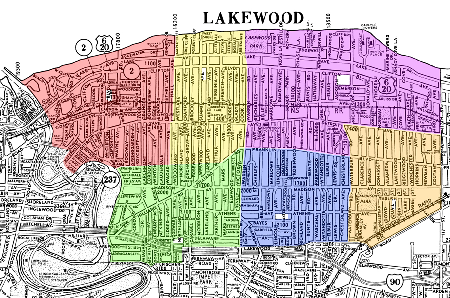
overlays ©2010 AGS
------------------------------------------------------------------------------------------------------------------------------------------------
However, the Administration had been unable to configure a map under a scenario wherein Lincoln stays open that looks similar to the following map – i.e., flip the Grant/Lincoln boundary from the south to the north – because there simply are not enough students actually residing north of Detroit to support such a configuration:
The map representing what the school district configuration would look like if Lincoln closed today, is as follows below:
overlays ©2010 AGS
------------------------------------------------------------------------------------------------------------------------------------------------
Under either of these hypothetical scenarios, you may not be maximizing the benefits of class size, geographic configuration, safety, walking distance, and neighborhood experience – all of which were found to be the most important factors (after obtaining state funding) at the April 2009 Community Forum.
Now, allow me the opportunity to take a step back and respond to the following comment from Robert:
The circles you have drawn speak for themselves, but they do not show where students actually reside.
Again, the two current maps created by the Administration are reported to be the best scenarios given present elementary enrollment data to maximize the benefits of class size, geographic configuration, safety, walking distance, and neighborhood experience – all of which were found to be the most important factors (after obtaining state funding) at the April 2009 Community Forum.
Since I started this thread with a Bill Trentel quote, it may be appropriate to end it with one since Bill explains the current maps very well:
Matt
Bill Trentel has some good objective advice. In the following quote, Bill reminds us of the importance of stepping back and looking at things from a perspective of someone who may or may not be involved in the Phase III process:
Bill Trentel wrote: I was just pointing out that MOST of the public doesn't know anything about Phase…. As you know I'm in communications and I find that probably the biggest error people have in communicating their messages wether it's a product, service, whatever is that they don't step back and look at it from the perspective of the average consumer. Sometimes your to close, take a step back.
http://www.lakewoodobserver.com/forum/viewtopic.php?f=7&t=8785&start=15
So, allow me the opportunity to take a step back and respond to the following comment from Mike:
Mike Davis wrote:Matt, it is abundantly obvious to this parent of school age children, that the walking distances will be shorter for children attending all 6 elementary schools by rebuilding Lincoln.
The two maps presented in this thread were created by the Administration and not by any group with any agenda - hidden or otherwise.
These two maps were created by the Administration to provide the best scenarios given present elementary enrollment data to maximize the benefits of class size, geographic configuration, safety, walking distance, and neighborhood experience – all of which were found to be the most important factors (after obtaining state funding) at the April 2009 Community Forum.
You may very well be able to configure a map under a scenario wherein Grant stays open that looks similar to the following map – i.e., flip the Lincoln/Grant boundary from the west to the east and draw students from the north to the south:
The map representing what the school district configuration would look like if Grant closed today, is as follows below:
overlays ©2010 AGS
------------------------------------------------------------------------------------------------------------------------------------------------
However, the Administration had been unable to configure a map under a scenario wherein Lincoln stays open that looks similar to the following map – i.e., flip the Grant/Lincoln boundary from the south to the north – because there simply are not enough students actually residing north of Detroit to support such a configuration:
The map representing what the school district configuration would look like if Lincoln closed today, is as follows below:
overlays ©2010 AGS
------------------------------------------------------------------------------------------------------------------------------------------------
Under either of these hypothetical scenarios, you may not be maximizing the benefits of class size, geographic configuration, safety, walking distance, and neighborhood experience – all of which were found to be the most important factors (after obtaining state funding) at the April 2009 Community Forum.
Now, allow me the opportunity to take a step back and respond to the following comment from Robert:
robert klann wrote:Thank you for posting the maps. It's time to analyze the maps in a similar fashion as before. See attached pdf file for walking distance circles applied to new boundaries.
The circles you have drawn speak for themselves, but they do not show where students actually reside.
Again, the two current maps created by the Administration are reported to be the best scenarios given present elementary enrollment data to maximize the benefits of class size, geographic configuration, safety, walking distance, and neighborhood experience – all of which were found to be the most important factors (after obtaining state funding) at the April 2009 Community Forum.
Since I started this thread with a Bill Trentel quote, it may be appropriate to end it with one since Bill explains the current maps very well:
Bill Trentel wrote:[T]he map with the central school would seem to force the two north (Horce Mann and Emerson) school boundaries to be geographically much larger but this is only because they are located in areas that are far less densely populated by students. The Gold Coast, the apartments on eastern Clifton Blvd. and Lakewood Park just aren't were students live. Likewise the central and three south schools geographic boundaries appear to be smaller and that is because they are located in areas that are more densely populated by students.
Matt
-
Mike Zannoni
- Posts: 154
- Joined: Fri Jan 23, 2009 11:36 am
- Location: Lakewood, OH
Re: A "Phase III Maps" Response
robert klann wrote:It's time to analyze the maps in a similar fashion as before. See attached pdf file for walking distance circles applied to new boundaries.
I agree fully, and thank you for that work. However, the notion that "no one needs dots on a map to realize that closing Lincoln will result in a larger number of Lakewood children being negatively impacted by having to walk longer distances" (text from your pdf) is erroneous, in my opinion. We need exactly that, because of density differences. Your work shows clearly that a larger land area is affected, but not that fewer students are affected.
Mike Davis wrote:A hanful of kids walking a little farther to school should not be the deciding factor of which school should be rebuilt. It is too small a number to sway a decision one way or another.
It shouldn't, and won't be THE "deciding factor", according to Matt. But I'm not convinced, as I said above, that it's truly only "a handful" we are speaking of. Aside from walking distance, safety and the disruption of neighborhoods are actually of far greater concern at this point, now that we have these boundary maps of the resulting closures. The number of children making Detroit crossings is troubling, to say the least, in the "Lincoln stays" scenario, as is the splitting of the Grant-area neighborhood into 5 pieces. The Lincoln-area neighborhood would be split in 2, by comparison, in the "Grant stays" scenario, with ZERO Detroit crossings.
As Christina McCallum said well of the Lincoln-stays scenario:
Christina McCullum wrote:It seems like we would want to keep neighborhood kids together as much as possible, walking away from major roads as much as possible. I notice that one scenario affecting three schools splits blocks in the North/South direction, so half the kids travel one way and half the other. This diminishes the possibility that families create Walking Schoolbuses, or that kids just meet up on the way to school for the safety in numbers effect. One scenario requires a lot of children to cross Detroit who otherwise would not have to . . .
I also am troubled by the idea of a three (or 4? some have said) story Lincoln on its tiny site. Why is this desirable by anybody, other than to save Lincoln at any cost, even if it ends up costing far more?
Matt Markling, quoting Bill Trentel, wrote:The small Lincoln site would require a three story building and would need to be placed off center on the site in-order to achieve the require amount outdoor play/activity space . . . 4 homes would need to be acquired, 2 on Summit and 2 on Lakeland to make the site large enough . . . construction logistics would be a challenge at the Lincoln site due to the lack of space to stage materials and place construction trailers and equipment
And finally, concerning this:
Mike Davis wrote:The views of the 300+ participants to the phase III forum should not be discarded because of the failure of the phase III committee to make a recommendation to the BOE.
After looking into this deeply, it is only right for that forum’s results to be discredited, no matter how many people attended: The District Configuration Sub-Committee’s unequivocal recommendation was improperly omitted in the presentation to the forum attendees, as was a full representation of their work. The same goes for the Building Sites Sub-Committee: Relevant architectural reports were not presented, which strongly bears on this decision. "Consensus" was not defined uniformly from table to table, for some tables meaning only "majority opinion" and for others meaning "unanimous agreement". There were credible reports of the designated dot-sticker-upper going against their table’s "majority opinion", or the agreed "lack of consensus", and placing the dot another card entirely.
And, not least importantly, "Land Re-Use" was erected at the 11th hour without vetting or study by the community sub-committees, with an obviously concomitant coaching and pre-arrangement for many who attended to seize upon this concept as the main reason for their decision. This strongly implies that this new criterion was created for and "leaked" to only those of a certain pre-disposition. This is a terrible abuse of the process, and therefore the results of the forum as a whole are truly invalid. That is why the Committee decided it could not recommend, because all of this was obvious to many who attended, including myself.
Speaking fairly, it is not the case that the final vote represented anything like "the views of the 300+ participants", and in light of all of the above, it doesn’t even fairly represent the properly informed views of many who voted in the majority. The process was deeply flawed and lacked credibility to me and many others. This lack of credibility for many participants is simply a fact that must be reckoned with, whether or not one believes or agrees with any of my comments above concerning that forum.
Mike Zannoni
Lakewoodite
Lakewoodite
-
Will Brown
- Posts: 496
- Joined: Sat Nov 10, 2007 10:56 am
- Location: Lakewood
Re: A "Phase III Maps" Response
I'll jump in late with a couple of points. First, we don't really have local control of our schools if we have the Federal and State governments telling us what we can and cannot do. But there's nothing we can do about that until the revolution.
It may be nice (but not necessary) in a less congested town, to have a large outside area for each school building. But practically speaking, such an area does not contribute at all to the educational process (unless we have classes in mowing and grazing) and, especially in a crowded town like Lakewood, is a very inefficient use of the land. The land is not used during the school day (there may be an occasional physical education class outside, but I think the teachers would rather have the classes inside, where it is easier to keep control of the kids, and where it doesn't rain or snow. So all this land is used for a few minutes before school, and that's it. The schools don't want other people using their land (take a grill over to the schoolyard and have a picnic; they'll almost certainly call the police). A few kids who live very close to the school can play there after school, but for the vast majority, that land is not useful.
So I think that for our community, having buildings that use all the land is a better option, as it provides more resources for the educational program.
As for walking to school, I don't think kids are so delicate that they cannot walk for quite a ways. Obviously the parents who are intent on worsening the epidemic of childhood obesity in our country think otherwise.
And as to crossing streets, even commercial streets, the kids are going to have to do it sooner or later. I would rather see them learn to do it when they are very young, and with guards in place, than to just unleash them to the middle schools to learn from their peers. My observation is that most parents do a very poor job of teaching this: they tell the kids how to do it properly, but they themselves frequently do it improperly, and the kids are smart enough to see through this.
I think a lot of the argument over which schools should be closed is based on flawed reasoning. If a child is benefiting from a good educational experience, it is because of the quality and involvement of the students, faculty (I include the administrators in this category) and parents. The building itself is almost irrelevant. If you could keep that community of involved people together, you could as easily be meeting in the pavilion at the park, or in a bunch of trailers.
So the most important question would be how we keep two good educational communities going, or if we must, how can we integrate them without losing anything.
Society in every state is a blessing, but the Government even in its best state is but a necessary evil...
-
Danielle Masters
- Posts: 1139
- Joined: Sat Jul 09, 2005 12:39 am
- Location: Lakewood, OH
Re: A "Phase III Maps" Response
Will Brown wrote:First, we don't really have local control of our schools if we have the Federal and State governments telling us what we can and cannot do.
Well the fact is we are asking for this funding to complete a building project and usually when you ask for funds from the government that are not available to everyone they come with strings attached. The community decided that rebuilding the schools was important and that getting these funds to help with the costs was important and in doing so we have to abide by the rules. Whether or not we agree with their rules it is something we signed onto and if we want the money to rebuild our schools we have to abide by the standards which include school size and such that the OSFC sets forward.
-
marklingm
- Posts: 2202
- Joined: Sat Jul 07, 2007 7:13 pm
- Location: The 'Wood
Re: A "Phase III Maps" Response
Jim O'Bryan wrote:But one of the things I think is important is - was Phase III a continuation of the 50-Year-Committee....
http://www.lakewoodobserver.com/forum/viewtopic.php?f=7&t=8791&p=67705#p67705
Jim,
The answer is, no. The original recommendation of the 50 Year Committee has no impact on my Phase III decision as the Board has taken a “clean slate approach,” which has been confirmed and endorsed by Jay Foran himself:
Jay Foran wrote:As you know, the state has indicated a willingness to only fund six elementary schools at this time.
Once that information was obtained, the Board properly made the decision to wipe the slate clean and reassess the original recommendation of the 50 Year Committee. Thus, Lincoln, Grant and Roosevelt were put in play as sites to consider.
I, like most other committee members, fully support the clean slate approach.
http://www.lakewoodobserver.com/forum/viewtopic.php?f=7&t=8479&p=64281#p64281
Matt
-
Mike Zannoni
- Posts: 154
- Joined: Fri Jan 23, 2009 11:36 am
- Location: Lakewood, OH
Re: A "Phase III Maps" Response
Will Brown wrote:As for walking to school, I don't think kids are so delicate that they cannot walk for quite a ways. Obviously the parents who are intent on worsening the epidemic of childhood obesity in our country think otherwise.
It seems that not everyone realizes just how many elementary students are walked to school by necessity every day by mothers (and fathers) with even younger children in tow and with babies in slings and in strollers. Walking distance matters a lot to some, especially in rain, snow or cold weather.
For the ages we are talking about, an extra 1/2 mile could make a difference to making it to school that day. By middle school, children are more usually walking by themselves and other students, not parents with other small children, and walking distance is far less of an issue.
Mike Zannoni
Lakewoodite
Lakewoodite
-
Bill Trentel
- Posts: 169
- Joined: Wed Sep 16, 2009 12:21 am
Re: A "Phase III Maps" Response
Will Brown wrote:It may be nice (but not necessary) in a less congested town, to have a large outside area for each school building. But practically speaking, such an area does not contribute at all to the educational process (unless we have classes in mowing and grazing) and, especially in a crowded town like Lakewood, is a very inefficient use of the land. The land is not used during the school day (there may be an occasional physical education class outside, but I think the teachers would rather have the classes inside, where it is easier to keep control of the kids, and where it doesn't rain or snow. So all this land is used for a few minutes before school, and that's it. The schools don't want other people using their land (take a grill over to the schoolyard and have a picnic; they'll almost certainly call the police). A few kids who live very close to the school can play there after school, but for the vast majority, that land is not useful.
Mr. Brown thank you for joining the discussion. The outdoor spaces at our elementary schools are not a luxury they are valuable education spaces not unlike a library or gym. They are used daily by the students during their recess period. (yes even in the winter) If you visit either Grant or Lincoln for instance you will find wonderful garden areas maintained by the students and staff which serve as outdoor classrooms.
Additionally you must keep in mind that the three remaining elementary schools that are being addressed in the Phase III process where built in a different time. These buildings where built when all the students went home for lunch each day. (hence no cafeteria's) And the teaching methods where far less dynamic.
As Danielle outlined, in order to take advantage of the state funding we must meet their guidelines which stipulate almost every aspect of the facility including outdoor spaces. Keeping in mind that these standards where designed to build new buildings on farm fields in places like Medina and Deleware counties. Lakewood needed numerous variances in order to complete phases I & II including not meeting the minimum outdoor space requirements. Other features of our new buildings that make them uniquely Lakewood's like the use of Lakewood appropriate materials and the reuse of historic elements where funded solely by the citizens of Lakewood because they where outside of the guidelines but very important to the citizens of Lakewood.
Bill
-
Bob Mehosky
- Posts: 91
- Joined: Wed Aug 19, 2009 9:20 am
Re: A "Phase III Maps" Response
Will Brown wrote:It may be nice (but not necessary) in a less congested town, to have a large outside area for each school building. But practically speaking, such an area does not contribute at all to the educational process (unless we have classes in mowing and grazing) and, especially in a crowded town like Lakewood, is a very inefficient use of the land. The land is not used during the school day (there may be an occasional physical education class outside, but I think the teachers would rather have the classes inside, where it is easier to keep control of the kids, and where it doesn't rain or snow. So all this land is used for a few minutes before school, and that's it. The schools don't want other people using their land (take a grill over to the schoolyard and have a picnic; they'll almost certainly call the police). A few kids who live very close to the school can play there after school, but for the vast majority, that land is not useful.
Unfortunately, the Ohio School Facilities Commission disagrees:
http://www.osfc.state.oh.us/LinkClick.a ... 65&mid=663
Ohio School Design Manual wrote:F. URBAN ELEMENTARY SCHOOL – 400 students
Building Footprint (One-Story) 50,000 SF 1.15 acres
K-2/3-5 Playgrounds (see Note 1) 20,000 SF 0.46 acre
Parking and Drives (see Note 2) 17,600 SF 0.40 acre
Play Fields (see Note 3):
One multipurpose field (360’ x 250’),
one softball field (200’ outfield),
and one basketball court 117,340 SF 2.69 acres
Subtotal 204,940 SF 4.70 acres
Add 20% Greenspace (see Note 4) 40,988 SF 0.94 acre
TOTAL 245,928 SF 5.64 acres
Recommended site size 5.75 acres
Note 1: This space footage, based on 50 SF per student, allows for a hard surface play
area and a soft surface play equipment area for each playground.
Note 2: This estimate of area, based on 400 SF per car, allows for drives, a dropoff/
pick-up zone, and a service area drive.
Note 3: Softball fields may partially overlap multipurpose field.
Note 4: 20% of the site square footage requirements as greenspace ensures adequate
space for separation of the various elements located on each site. Includes site
landscaping.