A "Phase III Maps" Response
Moderator: Jim O'Bryan
-
Mike Davis
- Posts: 45
- Joined: Wed Jan 21, 2009 11:18 pm
- Location: Lakewood
Re: A "Phase III Maps" Response
I am all about a stronger, better and more fun Lakewood with tight fiscal oversight.
-
Stephen Eisel
- Posts: 3281
- Joined: Fri Jan 26, 2007 9:36 pm
Re: A "Phase III Maps" Response
Yes, shouldn't Hayes be closer to I-90???? I see Harding on the first map (yellow area). Hayes is in the green area???? just asking (not a big error)Thanks for fixing the maps but Hayes is not in the proper spot. That is the site of Harding not Hayes
-
Jim O'Bryan

- Posts: 14196
- Joined: Thu Mar 10, 2005 10:12 pm
- Location: Lakewood
- Contact:
Re: A "Phase III Maps" Response
Stephen Eisel wrote:Yes, shouldn't Hayes be closer to I-90???? I see Harding on the first map (yellow area). Hayes is in the green area???? just asking (not a big error)Thanks for fixing the maps but Hayes is not in the proper spot. That is the site of Harding not Hayes
fixed I think.
thanks
Mike Davis
See in complete agreement.
.
Jim O'Bryan
Lakewood Resident
"The very act of observing disturbs the system."
Werner Heisenberg
"If anything I've said seems useful to you, I'm glad.
If not, don't worry. Just forget about it."
His Holiness The Dalai Lama
Lakewood Resident
"The very act of observing disturbs the system."
Werner Heisenberg
"If anything I've said seems useful to you, I'm glad.
If not, don't worry. Just forget about it."
His Holiness The Dalai Lama
-
Corey Rossen
- Posts: 1663
- Joined: Thu Nov 09, 2006 12:09 pm
Re: A "Phase III Maps" Response
Just commenting on the tone of your first entry about the meeting. You saw the maps and no one else did, the public will find out later - seemed "privy" to me. The facts were not presented until the next post. I'm just reading from the facts presented, at the time they were presented. Transparency after the fact is not transparency.Danielle Masters wrote:Corey I stated the maps were shown to a group of people and that I happened to be in that group. I chose to share that because I wanted to make sure I said everything that happened at the meeting. I never stated I was privy to anything. I quite clearly stated the maps were not ready last night because of the dots and that they were not part of the actual meeting. And I stated they were shown to a group of people by a board member and members of the administration. Sorry you are reading into things rather than responding to facts. I didn't want to leave anything out as I believe in transparency.
Corey
Corey Rossen
"I have neither aligned myself with SLH, nor BL." ~ Jim O'Bryan
"I am not neutral." ~Jim O'Bryan
"I am not here to stir up anything." ~Jim O'Bryan
"I have neither aligned myself with SLH, nor BL." ~ Jim O'Bryan
"I am not neutral." ~Jim O'Bryan
"I am not here to stir up anything." ~Jim O'Bryan
-
Bill Trentel
- Posts: 169
- Joined: Wed Sep 16, 2009 12:21 am
Re: A "Phase III Maps" Response
Mr. Markling, thank you for posting these edited versions of the maps. They are helpful to see what the boundaries might look like one vs. the other. But without the dots to illustrate were students will actually come from it is difficult to understand why they are shaped the way they are. For instance the map with the central school would seem to force the two north (Horce Mann and Emerson) school boundaries to be geographically much larger but this is only because they are located in areas that are far less densely populated by students. The Gold Coast, the apartments on eastern Clifton Blvd. and Lakewood Park just aren't were students live. Likewise the central and three south schools geographic boundaries appear to be smaller and that is because they are located in areas that are more densely populated by students.
My point is...without the dots it might be difficult for some to understand the justification of the boundaries.
Bill
My point is...without the dots it might be difficult for some to understand the justification of the boundaries.
Bill
-
Bill Trentel
- Posts: 169
- Joined: Wed Sep 16, 2009 12:21 am
Re: A "Phase III Maps" Response
Now that we've hashed-out the location element...
Some posters have implied that there are other issues that makes one location superior to the other, what are they?
We've be told by the BOE consultants that either site is build-able and financially a wash. And commercial value of either site has not been determined but assumed to be a wash. And both schools have great students, parents and staffs that achieve. What other facts are out there?
The popular vote held at the September Phase III meeting? OK, Lincoln is more popular.
Bill
-
marklingm

- Posts: 2202
- Joined: Sat Jul 07, 2007 7:13 pm
- Location: The 'Wood
Re: A "Phase III Maps" Response
Ryan Salo wrote:Matt,
Thanks for posting this.
I am hoping that there will be flexability for those kids living on Andrews and areas just north of Grant, if Lincoln closes.
Ryan,
You are welcome. These boundaries are flexible. They will "flex" as student residency shifts. They are also intended to allow for exceptions such as the one you mention above. See, also, my response to Corey’s question below.
One benefit of a centrally located school is the ability to maximize flexibility.
Matt
-
marklingm
- Posts: 2202
- Joined: Sat Jul 07, 2007 7:13 pm
- Location: The 'Wood
Re: A "Phase III Maps" Response
Corey Rossen wrote:Ryan Salo wrote:Matt,
Thanks for posting this.
I am hoping that there will be flexability for those kids living on Andrews and areas just north of Grant, if Lincoln closes.
Open enrollment would still exist, correct? Are ther qualifiers, or open to anyone who fills out an application?
Corey,
You are welcome. There is no plan to change the current open enrollment policy and guidelines.
Matt
-
marklingm
- Posts: 2202
- Joined: Sat Jul 07, 2007 7:13 pm
- Location: The 'Wood
Re: A "Phase III Maps" Response
Bill Trentel wrote:Mr. Markling, thank you for posting these edited versions of the maps. They are helpful to see what the boundaries might look like one vs. the other. But without the dots to illustrate were students will actually come from it is difficult to understand why they are shaped the way they are….
My point is...without the dots it might be difficult for some to understand the justification of the boundaries.
Bill,
You are welcome. Actually, the specific dot locations are immaterial because you explain it perfectly. For those who may be confused, Bill is correct when he says:
Bill Trentel wrote:[T]he map with the central school would seem to force the two north (Horce Mann and Emerson) school boundaries to be geographically much larger but this is only because they are located in areas that are far less densely populated by students. The Gold Coast, the apartments on eastern Clifton Blvd. and Lakewood Park just aren't were students live. Likewise the central and three south schools geographic boundaries appear to be smaller and that is because they are located in areas that are more densely populated by students.
Bill’s analysis explains the following map very well:
The map representing what the school district configuration would look like if Lincoln closed today, is as follows below:
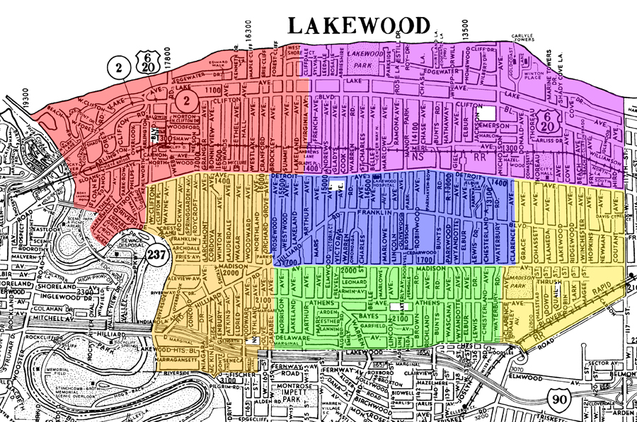
overlays ©2010 AGS
------------------------------------------------------------------------------------------------------------------------------------------------
See, also, my response to Jim below.
Matt
-
marklingm
- Posts: 2202
- Joined: Sat Jul 07, 2007 7:13 pm
- Location: The 'Wood
Re: A "Phase III Maps" Response
Jim O'Bryan wrote:Matt
I noticed that the maps appear larger but is this also based on walkable desnsity? So these maps are based on two or more criteria?
Jim,
If you look at the map representing what the school district configuration would look like if Lincoln closed today (below), there are only two elementary schools north of Detroit because there simply are not enough elementary students currently residing north of Detroit to support more than two elementary schools north of Detroit in that scenario. And, all boundaries are drawn to limit walking distances as much as possible.
overlays ©2010 AGS
------------------------------------------------------------------------------------------------------------------------------------------------
Bill Trentel actually explains it well as follows:
Bill Trentel wrote:[T]he map with the central school would seem to force the two north (Horce Mann and Emerson) school boundaries to be geographically much larger but this is only because they are located in areas that are far less densely populated by students. The Gold Coast, the apartments on eastern Clifton Blvd. and Lakewood Park just aren't were students live. Likewise the central and three south schools geographic boundaries appear to be smaller and that is because they are located in areas that are more densely populated by students.
Matt
-
Meg Ostrowski
- Posts: 466
- Joined: Sun Apr 19, 2009 10:42 am
Re: A "Phase III Maps" Response
It may also be helpful to know that Horace Mann and Emerson (as renovated) are able to accommodate 502 students each compared to (rebuilt) Harrison and Hayes at 472. It is my understanding that capacities at Grant, Lincoln or Roosevelt would be planned for 472, according to documents provided to members of the Phase III Committee.
I agree that a centrally located school would provide the district maximum flexibility. I also think a slightly larger centrally located school would avoid having to redraw boundaries annually. When enrollment numbers rise close to capacity we are at greater risk for large class sizes and/or constant disruption to neighborhoods, families and learning.
I still believe that with new facilities, an ODE EXCELLENT designation for the district, families struggling to pay private school tuition and Lakewood being identified as a BEST PLACE TO RAISE A FAMILY by BusinessWeek, we can expect our enrollment to increase (it did this school year)...of course it could just be a bubble.
I have attended a couple of the city's Parks Master Planning meetings and at both it was brought up by attendees that a centrally located soceer/lacrosse field that could double as festival grounds would bring leagues, tournaments and festivals to Lakewood. This would naturally support downtown businesses and generate additional revenue for the district. Since the idea of bringing the schools and city together at Kauffman didn't fly, I'd like to see the district take advantage of the possibilites for the large, oddly shaped, centrally located Grant or Grant/BOE site...with historical buildings intact.
It seems everyone around here is working separately but I am hopeful I will hear otherwise at next week's joint session of City Council and the BOE.
“There could be anywhere from 1 to over 50,000 Lakewoods at any time. I’m good with any of those numbers, as long as it’s just not 2 Lakewoods.” -Stephen Davis
-
Mike Zannoni
- Posts: 154
- Joined: Fri Jan 23, 2009 11:36 am
- Location: Lakewood, OH
Re: A "Phase III Maps" Response
Danielle Masters wrote: . . .my numbers of 60 and 120 once again came from the phase III community meeting. They said that if Grant was removed 120 students would be 3/4 of a mile or further from an elementary building and that 60 would be further with Lincoln removed. That is the aftermath of a school closing . . .
Are these numbers (60/120) based on the reconfigured boundries for all schools, per Matt's maps in this thread? Because in the "Grant stays open" scenario" some number in that density zone we're concerned about will not go to Grant, as I'd thought originally, but to Hayes. Right?
Mike Zannoni
Lakewoodite
Lakewoodite
-
Danielle Masters
- Posts: 1139
- Joined: Sat Jul 09, 2005 12:39 am
- Location: Lakewood, OH
Re: A "Phase III Maps" Response
I'm not sure I have the answer for you Mike. I am going
by the information provided to the community during the community forum. My understanding is that since the population
density of school age children is higher in the center of the city that removing the remaining school in the center of town would make it so that larger
group
of children would have
to travel either north or south to attend a school. I am not sure how the maps that have been provided will affect
that.
-
Mike Zannoni
- Posts: 154
- Joined: Fri Jan 23, 2009 11:36 am
- Location: Lakewood, OH
Re: A "Phase III Maps" Response
Danielle Masters wrote: . . . I am going by the information provided to the community during the community forum . . .
The thing to do now is look at these two maps provided in light of walk length and safety. I don't think the old walk numbers will be accurate, but it's clear that in the "Grant stays" scenario, no child will be crossing Detroit. Zero. But in the "Lincoln stays" scenario, a good number of kids would be crossing Detroit to go to school. This is clearly undesirable.
It's also clear that few if any former Lincoln students would go to Grant, if Grant stays open—even if they live very close to Grant, north of Detroit. So that fear of Dee Martinez, I think it was, that Edgewater kids would be crossing both Clifton and Detroit to get to school is also not relevant in light of the "all schools reconfigured" boundaries.
Mike Zannoni
Lakewoodite
Lakewoodite
-
marklingm
- Posts: 2202
- Joined: Sat Jul 07, 2007 7:13 pm
- Location: The 'Wood
Re: A "Phase III Maps" Response
Mike Davis wrote:Once you see how difficult it is to get the community to attend and participate in an important community meeting, the 300 plus that attended the Phase 3 meeting was huge. I have been very disapointed in the attempt by many posts on the deck aimed at trying to discredit or minimize my opinion and the opinions of everyone else in attendance that night that were recorded and reported.
Mike,
I, for one, value your opinion and everyone’s opinion who attends any and all of our forums. That being said, many forget that the Phase III Committee did not make any building closing recommendation to the Board. Again, absolutely no building closing recommendation was made to the Board.
I am not persuaded by the argument that, “Had the Phase III Committee made a such recommendation, it would have been to close X.” I have reviewed all the information presented to me by the Phase III Committee and it is certainly not abundantly obvious to this school board member what the Phase III Committee would have recommended had that committee actually made a recommendation. What is abundantly obvious to this board member is that absolutely no recommendation was made by the Phase III Committee with respect to the closing of either Lincoln or Grant, period.
The fact of the matter is that the Board has more information before it now than was either before the Phase III Committee itself or those 300 plus attendees that the Phase III meeting. Why does the Board have more information? Because the only recommendation that was, in fact, made by the Phase III Committee was to consider additional information beyond that which was gathered by either the Phase III Committee itself or those 300 plus attendees that the Phase III meeting.
Mike, as a participant of the Phase III meeting, you know that there was absolutely no discussion regarding the enormous hurdles placed upon school boards by the Ohio General Assembly in disposing of school property. See, e.g., R.C. 3313.41 entitled, “Disposal of real or personal property.” The Legislature placed these hurdles before school boards to ensure that school properties are used for school purposes before exploring other opportunities. While we may or may not agree with the decision of the Ohio General Assembly, those are the rules of the game.
Mike, as a participant of the Phase III meeting, you know that there was absolutely no discussion regarding any economic development plans for any of our properties by either the City or the Board – because no such plans exist. See above explanation as to the disposal of school property.
Mike, as a participant of the Phase III meeting, you know that the current economic value of either Grant or Lincoln is a wash. That fact has been reiterated to me again and again by the Administration.
Mike, as a participant of the Phase III meeting, you know that our architectural firm ranked Grant as a better site for an elementary school than Lincoln given the parameters set forth by the State of Ohio.
Mike, as a participant of the Phase III meeting, you know that keeping Lincoln will require a complete rebuild to accommodate the increased number of students, and that Lincoln simply will not be historically preserved in the truest of terms.
Mike, as a participant of the Phase III meeting, you know that more parents of certain attendance areas were in attendance than other areas. That fact should not be seen as a negative on those parents, and non-parents, who attended the Phase III meeting but nor should the forum be seen as a “referendum” based upon who was able to “get out the vote.” See below.
Mike, as a participant of the Phase III meeting, you know that some tables decided to cast a “vote” rather than work toward “consensus.” That was not the ground rule.
Mike, as a participant of the Phase III meeting, you are aware that many tables were unable to reach any consensus and did not cast a vote. I am not persuaded by the argument that, “Had those tables that were unable to reach consensus done so, it would have been in favor of closing X.” I have reviewed all the information presented to me by the Phase III Committee and it is abundantly obvious to this school board member that no consensus was reached at those tables because they simply could not reach consensus - nothing more, and nothing less.
I share the above points not so much for you, Mike, because you were a participant of the Phase III meeting. I share these points mainly for my fellow Observers who have either not read the two enormous binders prepared by the Phase III Committee and/or were unable to attend the Phase III meeting.
Nonetheless, and to be abundantly clear, to the extent the Phase III Committee or participants of the Phase III forum made any recommendation – whatsoever – relating to student density, safety, or distances, it is the opinion of this board member that such a recommendation was not based upon current, accurate data because that data was not presented to the Board until this past week and is memorialized within the two maps set forth below.
The map representing what the school district configuration would look like if Lincoln closed today, is as follows below:
overlays ©2010 AGS
------------------------------------------------------------------------------------------------------------------------------------------------
The map representing what the school district configuration would look like if Grant closed today, is as follows below:
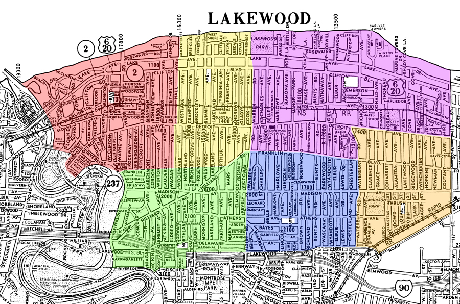
overlays ©2010 AGS
Matt